Directory of Map Projections
 Cylindric
- БСАМ
- Карченко-Шабанова
- Урмаева III
- цилиндрическая Павлова
- Braun cylindric
- BSAM
- Cassini
- Cassini-Soldner
- central cylindric
- cylindric equal-area
- Balthasart
- Behrmann equal-area
- Craster rectangular equal-area
- cylindric equal-area
- Gall orthographic
- Gall-Peters
- Hobo-Dyer
- Lambert equal-area cylindric
- Peters
- Smyth equal-surface
- Tobler world in a square
- Trystan Edwards
- equidistant cylindric
- equirectangular
- Gall isographic
- Gall stereographic
- geographic projection
- Karchenko-Shabanova
- la carte parallélogrammatique
- lat⁄lon
- Marinus
- Mercator
- complex latitude plane
- ellipsoidal Mercator
- ellipsoidal oblique Mercator
- ellipsoidal transverse Mercator
- Gauss conformal
- Gauss Hannover
- Gauss-Krüger
- Gauss-Schreiber
- Hotine
- Mercator
- oblique cylindric orthomorphic
- rectified skew orthomorphic
- Thompson transverse Mercator
- transverse cylindric orthomorphic
- Universal Transverse Mercator
- UTM
- Wallis 1 transverse Mercator
- Wallis 2 transverse Mercator
- Web maps Mercator
- Wright
- Miller cylindric
- Patterson
- Pavlov cylindric
- perspective cylindric
- plane chart
- plate carrée
- rectangular
- simple cylindric
- simple perspective cylindric
- transverse plate carrée
- Urmayev III
 Pseudocylindric
- Apian II
- Apianus II
- Atlantis
- Babinet
- Boggs eumorphic
- Bomford modified Gall
- Bromley
- Cabot
- Collignon
- Craster parabolic
- Eckert
- elliptical
- Equal Earth
- equal-area polynomial
- Foucaut
- Fournier II
- Gall-Bomford
- Goode homolosine
- Hölzel
- Hatano asymmetric
- HEALPix
- homalographic
- homolographic
- homolosine
- Hufnagel I
- Hufnagel
- Hufnagel
- Hufnagel II
- Hufnagel III
- Hufnagel IV
- Hufnagel IX
- Hufnagel V
- Hufnagel VII
- Hufnagel X
- Hufnagel XI
- Hufnagel XII
- hyperelliptical
- Kavrayskiy
- loximuthal
- McBryde S3
- McBryde-Thomas
- III
- IV
- McBryde-Thomas flat-pole parabolic
- McBryde-Thomas flat-pole quartic
- McBryde-Thomas flat-pole sinusoidal
- McBryde-Thomas I
- McBryde-Thomas II
- V
- Mercator equal-area
- Mollweide
- Natural Earth
- Nell
- Nell-Hammer
- orthophanic
- Philbrick Sinu-Mollweide
- Putniṇš P4
- Putniṇš
- Putniṇš P1
- Putniṇš P1´
- Putniṇš P2
- Putniṇš P3
- Putniṇš P3´
- Putniṇš P4´
- Putniṇš P5
- Putniṇš P5´
- Putniṇš P6
- Putniṇš P6´
- quartic authalic
- Robinson
- Sanson-Flamsteed
- simple equal-area homotopy
- sinucyli
- sinusoidal
- Snyder minimum-error
- The Times
- Tobler-Mercator
- trapezoidal
- Urmayev
- Wagner
- Winkel
 Conic
Conic- Albers equal-area conic
- Albers-Bonne homotopy
- Albers-Lambert homotopy
- American polyconic
- amulet
- bipolar oblique conic conformal
- Bonne
- Boole
- Bottomley
- Braun stereographic conic
- conical orthomorphic
- dépôt de la guerre
- ellipsoidal Lambert conformal conic
- equal-area pseudoconic
- equidistant conic
- Gauss conformal conic
- globe gores
- Harding
- heart
- Herschel conformal conic
- isoperimetric cordiform
- Lambert conformal conic
- Lambert equal-area conic
- modified Flamsteed
- optimized Albers
- ordinary polyconic
- périgonale equal-area conic
- perspective conic
- polyconic
- Ptolemy
- rectangular polyconic
- shield
- simple conic
- Stab-Werner
- Tissot equal-area conic
- War Office
- Werner
 Azimuthal
- Airy
- azimuthal equidistant
- azimuthal extruded globe
- Berghaus star
- Breusing
- Canters EU
- Chamberlin trimetric
- Close
- doubly azimuthal
- doubly equidistant
- fisheye
- Immler
- isoperimetric pseudoazimuthal
- Lambert azimuthal equal-area
- Lorgna
- McCaw
- Miller oblated stereographic
- orthodromic
- perspective
- AMS lunar
- analemma
- central
- Clarke twilight
- far-side perspective
- Fischer far-side perspective
- gnomic
- gnomonic
- Gretschel
- horologium
- James far-side perspective
- Lowry
- orthographic
- planisphærium
- stereographic
- tilted perspective
- vertical perspective
- Postel
- quasiazimuthal equal-area apple
- quasiazimuthal equal-area polygon
- regular star
- retroazimuthal
- Craig retroazimuthal
- Hammer retroazimuthal back hemisphere
- Hammer retroazimuthal front hemisphere
- Littrow
- Mecca
- Weir azimuthal
- two-point azimuthal
- two-point equidistant
- Wiechel
- zenithal equal-area
- zenithal equidistant
- zenithal equivalent
 Lenticular
- A4
- Aitoff
- Briesemeister
- Dietrich-Hammer homotopy
- Dietrich-Kitada
- Eckert-Greifendorff
- Ginzburg
- Gott equal-area elliptical
- Gott-Mugnolo equal-area elliptical
- Hammer
- Hammer-Aitoff
- hamusoidal
- kiss
- Strebe
- Strebe 1995
- Strebe asymmetric
- Strebe equal-areas
- cartouche
- Strebe-Hammer
- Strebe-Kavrayskiy V
- Strebe-Mollweide
- Strebe-sinusoidal
- Strebe-Snyder flat-pole
- Strebe-Snyder pointed-pole
- Wagner
- Winkel tripel
 Miscellaneous
- ЦНИИГАиК
- ابوریحان بیرونی
- Adams
- Adams hemisphere in a square
- Adams world in a hexagon
- Adams world in a square I
- Adams world in a square II
- Al-Bīrūnī
- Apian globular I
- Apian globular II
- Apianus globular I
- Apianus globular II
- armadillo
- Arrowsmith globular
- August
- August epicycloidal
- Bacon globular
- Cahill conformal butterfly
- Cahill-Concialdi bat
- chaise lounge conformal
- conformal world in an ellipse
- Cox world in a triangle
- Denoyer semi-elliptical
- dymaxion-like conformal
- Eisenlohr
- Fournier globular I
- Gilbert two-world perspective
- Ginzburg VIII
- Glareanus globular
- great circle equal-area tetrahedron
- GS50
- Guyou
- Lagrange
- Larrivée
- lateral equidistant
- Loritz globular
- masque
- Nicolosi globular
- oblated Lagrange
- Ortelius oval
- Peirce quincuncial
- polyhedron conformal face
- pseudorthographic
- quincuncial
- Raisz
- small circle equal-area tetrahedron
- Snyder equal-area tetrahedron
- tri-optimal
- TsNIIGAiK
- van der Grinten
- apple shaped
- van der Grinten
- van der Grinten I
- van der Grinten II
- van der Grinten III
- van der Grinten IV
- van Leeuwen
stereographic
planisphærium
Classifications
azimuthal
polyconic
conformal
perspective
Graticule
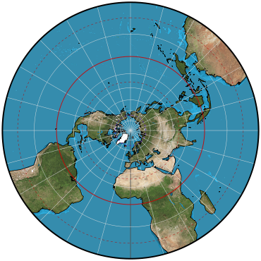
Polar aspect:.
Meridians: Equally spaced straight lines intersecting at central pole. Angles between them are the true angles.
Parallels: Unequally spaced circles centered at the pole, which is a point. Opposite pole cannot be shown. Spacing gradually increases away from the pole.
Symmetry: About any meridian.
Equatorial aspect:.
Meridians: Central meridian is a straight line. Other meridians are unequally spaced circular arcs intersecting at each pole. Spacing gradually increases away from the central meridian.
Parallels: Equator is a straight line. Other parallels are unequally spaced circular arcs concave toward the nearest pole. Spacing gradually increases away from the equator along the central meridian, but spacing is equal along the meridians 90° from the central meridian.
Symmetry: About the central meridian or the equator.
Oblique aspect:.
Meridians: Central meridian is a straight line. Other meridians are circular arcs intersecting at each pole and having their centers on the straight parallel opposite in sign to the central latitude. Spacing gradually increases away from the central meridian.
Parallels: The parallel opposite in sign to the central latitude is a straight line perpendicular to the central meridian. All other parallels are circular arcs concave toward the pole on the same side of the straight parallel.
Symmetry: About the central meridian.
Range
One hemisphere conveniently; most but not all of the other hemisphere at accelerating scale.
Scale
True only where the central latitude crosses the central meridian or, alternatively, along a circle concentric about the projection center (or a parallel on the polar aspect). Scale is constant along any circle having its center at the projection center, but scale increases moderately with distance from the center within a hemisphere.
Distortion
Only the center or the circle of true scale (if not the center) is free from all distortion.
Special features
All great or small circles (including all meridians and parallels) on the globe are shown as circular arcs or straight lines. Perspective projection of the globe onto a tangent (or secant) plane from a point on the surface just opposite the point of tangency or the projection center. The straight parallel of latitude passes through this point.
Usage Commonly used in the polar aspect for topographic maps of polar regions. The equatorial aspect was used regularly for maps of the Eastern and Western Hemispheres in the 17th and 18th centuries. Oblique aspects are used to show paths of solar eclipses.
Recommended for conformal mapping of regions approximately circular in shape.
Basis of modified Stereographic conformal projections using complex algebra, such as the Miller Oblated Stereographic.
Origin
Apparently developed in polar aspect by Egyptians and Greeks by the 2d century B.C.
Description adapted from J.P. Snyder and P.M. Voxland, An Album of Map Projections, U.S. Geological Survey Professional Paper 1453. United States Government Printing Office: 1989.