Directory of Map Projections
 Cylindric
- БСАМ
- Карченко-Шабанова
- Урмаева III
- цилиндрическая Павлова
- Braun cylindric
- BSAM
- Cassini
- Cassini-Soldner
- central cylindric
- cylindric equal-area
- Balthasart
- Behrmann equal-area
- Craster rectangular equal-area
- cylindric equal-area
- Gall orthographic
- Gall-Peters
- Hobo-Dyer
- Lambert equal-area cylindric
- Peters
- Smyth equal-surface
- Tobler world in a square
- Trystan Edwards
- equidistant cylindric
- equirectangular
- Gall isographic
- Gall stereographic
- geographic projection
- Karchenko-Shabanova
- la carte parallélogrammatique
- lat⁄lon
- Marinus
- Mercator
- complex latitude plane
- ellipsoidal Mercator
- ellipsoidal oblique Mercator
- ellipsoidal transverse Mercator
- Gauss conformal
- Gauss Hannover
- Gauss-Krüger
- Gauss-Schreiber
- Hotine
- Mercator
- oblique cylindric orthomorphic
- rectified skew orthomorphic
- Thompson transverse Mercator
- transverse cylindric orthomorphic
- Universal Transverse Mercator
- UTM
- Wallis 1 transverse Mercator
- Wallis 2 transverse Mercator
- Web maps Mercator
- Wright
- Miller cylindric
- Patterson
- Pavlov cylindric
- perspective cylindric
- plane chart
- plate carrée
- rectangular
- simple cylindric
- simple perspective cylindric
- transverse plate carrée
- Urmayev III
 Pseudocylindric
- Apian II
- Apianus II
- Atlantis
- Babinet
- Boggs eumorphic
- Bomford modified Gall
- Bromley
- Cabot
- Collignon
- Craster parabolic
- Eckert
- elliptical
- Equal Earth
- equal-area polynomial
- Foucaut
- Fournier II
- Gall-Bomford
- Goode homolosine
- Hölzel
- Hatano asymmetric
- HEALPix
- homalographic
- homolographic
- homolosine
- Hufnagel I
- Hufnagel
- Hufnagel
- Hufnagel II
- Hufnagel III
- Hufnagel IV
- Hufnagel IX
- Hufnagel V
- Hufnagel VII
- Hufnagel X
- Hufnagel XI
- Hufnagel XII
- hyperelliptical
- Kavrayskiy
- loximuthal
- McBryde S3
- McBryde-Thomas
- III
- IV
- McBryde-Thomas flat-pole parabolic
- McBryde-Thomas flat-pole quartic
- McBryde-Thomas flat-pole sinusoidal
- McBryde-Thomas I
- McBryde-Thomas II
- V
- Mercator equal-area
- Mollweide
- Natural Earth
- Nell
- Nell-Hammer
- orthophanic
- Philbrick Sinu-Mollweide
- Putniṇš P4
- Putniṇš
- Putniṇš P1
- Putniṇš P1´
- Putniṇš P2
- Putniṇš P3
- Putniṇš P3´
- Putniṇš P4´
- Putniṇš P5
- Putniṇš P5´
- Putniṇš P6
- Putniṇš P6´
- quartic authalic
- Robinson
- Sanson-Flamsteed
- simple equal-area homotopy
- sinucyli
- sinusoidal
- Snyder minimum-error
- The Times
- Tobler-Mercator
- trapezoidal
- Urmayev
- Wagner
- Winkel
 Conic
Conic- Albers equal-area conic
- Albers-Bonne homotopy
- Albers-Lambert homotopy
- American polyconic
- amulet
- bipolar oblique conic conformal
- Bonne
- Boole
- Bottomley
- Braun stereographic conic
- conical orthomorphic
- dépôt de la guerre
- ellipsoidal Lambert conformal conic
- equal-area pseudoconic
- equidistant conic
- Gauss conformal conic
- globe gores
- Harding
- heart
- Herschel conformal conic
- isoperimetric cordiform
- Lambert conformal conic
- Lambert equal-area conic
- modified Flamsteed
- optimized Albers
- ordinary polyconic
- périgonale equal-area conic
- perspective conic
- polyconic
- Ptolemy
- rectangular polyconic
- shield
- simple conic
- Stab-Werner
- Tissot equal-area conic
- War Office
- Werner
 Azimuthal
- Airy
- azimuthal equidistant
- azimuthal extruded globe
- Berghaus star
- Breusing
- Canters EU
- Chamberlin trimetric
- Close
- doubly azimuthal
- doubly equidistant
- fisheye
- Immler
- isoperimetric pseudoazimuthal
- Lambert azimuthal equal-area
- Lorgna
- McCaw
- Miller oblated stereographic
- orthodromic
- perspective
- AMS lunar
- analemma
- central
- Clarke twilight
- far-side perspective
- Fischer far-side perspective
- gnomic
- gnomonic
- Gretschel
- horologium
- James far-side perspective
- Lowry
- orthographic
- planisphærium
- stereographic
- tilted perspective
- vertical perspective
- Postel
- quasiazimuthal equal-area apple
- quasiazimuthal equal-area polygon
- regular star
- retroazimuthal
- Craig retroazimuthal
- Hammer retroazimuthal back hemisphere
- Hammer retroazimuthal front hemisphere
- Littrow
- Mecca
- Weir azimuthal
- two-point azimuthal
- two-point equidistant
- Wiechel
- zenithal equal-area
- zenithal equidistant
- zenithal equivalent
 Lenticular
- A4
- Aitoff
- Briesemeister
- Dietrich-Hammer homotopy
- Dietrich-Kitada
- Eckert-Greifendorff
- Ginzburg
- Gott equal-area elliptical
- Gott-Mugnolo equal-area elliptical
- Hammer
- Hammer-Aitoff
- hamusoidal
- kiss
- Strebe
- Strebe 1995
- Strebe asymmetric
- Strebe equal-areas
- cartouche
- Strebe-Hammer
- Strebe-Kavrayskiy V
- Strebe-Mollweide
- Strebe-sinusoidal
- Strebe-Snyder flat-pole
- Strebe-Snyder pointed-pole
- Wagner
- Winkel tripel
 Miscellaneous
- ЦНИИГАиК
- ابوریحان بیرونی
- Adams
- Adams hemisphere in a square
- Adams world in a hexagon
- Adams world in a square I
- Adams world in a square II
- Al-Bīrūnī
- Apian globular I
- Apian globular II
- Apianus globular I
- Apianus globular II
- armadillo
- Arrowsmith globular
- August
- August epicycloidal
- Bacon globular
- Cahill conformal butterfly
- Cahill-Concialdi bat
- chaise lounge conformal
- conformal world in an ellipse
- Cox world in a triangle
- Denoyer semi-elliptical
- dymaxion-like conformal
- Eisenlohr
- Fournier globular I
- Gilbert two-world perspective
- Ginzburg VIII
- Glareanus globular
- great circle equal-area tetrahedron
- GS50
- Guyou
- Lagrange
- Larrivée
- lateral equidistant
- Loritz globular
- masque
- Nicolosi globular
- oblated Lagrange
- Ortelius oval
- Peirce quincuncial
- polyhedron conformal face
- pseudorthographic
- quincuncial
- Raisz
- small circle equal-area tetrahedron
- Snyder equal-area tetrahedron
- tri-optimal
- TsNIIGAiK
- van der Grinten
- apple shaped
- van der Grinten
- van der Grinten I
- van der Grinten II
- van der Grinten III
- van der Grinten IV
- van Leeuwen
ellipsoidal Lambert conformal conic
Gauss conformal conic
Boole
Aspects of: Lambert conformal conic
Parameters: Latitude of origin, Standard parallel 1, Standard parallel 2
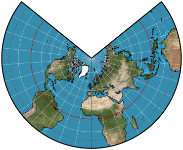
Description
The ellipsoidal form of the Lambert conformal conic projection. Two parallels can be designated to have the same scale, with that scale being deemed true scale.
Classifications
conic
conformal
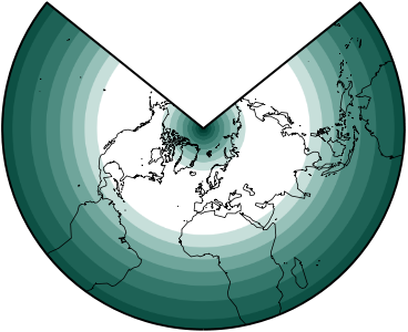
Graticule
Meridians: Straight lines, infinite in extent in a full world projection.
Parallels: Arcs of circles.
Poles: One is a point; one is at an infinite distance.
Parameters
Latitude of origin: The latitude at which the central meridian is deemed to have a value of (0, 0). This setting has non visible effect; its purpose is to yield plane coordinates that match other sources.
Standard parallel 1: Parallel along which scale is to be correct.
Standard parallel 2: Parallel along which scale is to be correct.
Usage
The Lambert conformal conic is used extensively in aeronautical charts and in national mapping systems. It excels at low-distortion portrayals of regions of long east-west extent. Optimizing the projection for the space is complicated, but a useful rule is to place the standard parallels ⅙th the way in from the maximum north-south extent of the map.
Origin
Johann Heinrich Lambert presented the projection in 1772.
Description ©2010–2020 Mapthematics LLC.