Classifications
azimuthal
minimum-error
Graticule
Polar aspect:.
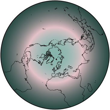
Meridians: Equally spaced straight lines intersecting at the central pole. Angles between them are the true angles.
Parallels: Nearly but not quite equally spaced circles, centered at the pole, which is a point. Spacing increases slightly away from the center.
Symmetry: About any meridian.
Equatorial aspect:.
Meridians: Central meridian is a straight line. Meridians 90° away are circles. Other meridians are complex curves, unequally spaced along the equator and intersecting at each pole. Spacing increases slightly away from the central meridian.
Parallels: Equator is a straight line. Other parallels are complex curves concave toward the nearest pole. They are unequally spaced along the central meridian, and spacing increases slightly away from the equator. At the meridian 90° from the central meridian, parallels are equally spaced.
Symmetry: About the central meridian or the equator.
Oblique aspect:.
Meridians: Central meridian is a straight line. Other meridians are complex curves intersecting at each pole.
Parallels: Complex curves unequally spaced along the central meridian; spacing increases slightly away from the center ol projection.
Symmetry: About the central meridian.
Range
Should be limited to about a hemisphere or less.
Scale
Scale increases gradually in all directions with distance from the center, but there is no point at which the scale is correct in all directions.
Distortion
Distortion is moderate throughout the range chosen. No point is completely free of distortion, although the center is free of shape distortion.
Special features
The minimum-error azimuthal projection of the region enclosed by a great or small circle of chosen radius from a given center.
Usage
Medium-scale Ordnance Survey map of the United Kingdom.
Similar projections
Clarke and James minimum-error perspective azimuthal projections were inspired by Airy's work.
The azimuthal equidistant projection closely resembles the Airy, but scale is constant along radii from the center.
In 1892, A. Breusing proposed the low-error geometric mean of the Stereographic and Lambert azimuthal equal-area projections.
In 1920, A.E. Young of England modified the Breusing (geometric mean) projection to provide a balance between the Stereographic and azimuthal equidistant projections, called the Breusing Harmonic projection.
In 1950, N.A. Urmayev of the Soviet Union proposed two other low-error azimuthal projections.
Origin
Presented by George Biddell Airy (1801-92), British astronomer and geodesist, in 1861.
Description adapted from J.P. Snyder and P.M. Voxland, An Album of Map Projections, U.S. Geological Survey Professional Paper 1453. United States Government Printing Office: 1989.
 Cylindric
 Pseudocylindric
 Conic
Conic Azimuthal
 Lenticular
 Miscellaneous

