Tobias--
Maybe the parentheses in my formula for X, for PF8.32-1, were incorrect, or ambiguous.
That incorrect or ambiguous use of parentheses in my formula might have been the reason why the formula didn't give the right result when you posted an image from it.
So let me reword the formula for X:
Maybe it would work right, in the following form:
X = 2f (lon/180) (1 - (abs(y))^p)
As before,
Y = lat/90
p = 8.32
f = .709326391
Michael Ossipoff
Eckert IV vs Eckert VI. Other related topics.
-
RogerOwens
- Posts: 403
- Joined: Sun Feb 02, 2014 8:24 pm
-
Atarimaster
- Posts: 457
- Joined: Fri Nov 07, 2014 2:43 am
Re: Eckert IV vs Eckert VI. Other related topics.
Well, I’m giving up in trying to do a JavaScript implementation for d3.js. It still doesn’t work and I fail to see what I’m doing wrong.
Since I feel much more comfortable with PHP, I tried it using this language. To be honest, I was doing it quite quick & dirty, just to see if I get any decent result at all.
The function is as simple as it gets:
Then, I ran a tiny script calling this function and creating a dot at each lon/lat-coordinate that is passed to the function.
I chose a two degree increment and these are the result that I got:
I think that looks quite right. However, I really just changed JavaScript syntax to PHP syntax, e.g. when I wrote Math.abs(y) in JS, I wrote abs($y) in PHP.
Nonetheless while it works in PHP, it doesn’t in JS. So maybe I’m misunderstanding how to use the function within the d3.js scripts or whatever, I really have no idea.
It really bugs me that I’m too stupid to figure this out.
Since I feel much more comfortable with PHP, I tried it using this language. To be honest, I was doing it quite quick & dirty, just to see if I get any decent result at all.
The function is as simple as it gets:
Code: Select all
function ossipoff($lon, $lat) {
    $p = 8.32;
    $f = 0.709326391;

    $y = $lat/90;
    $x = 2 * $f * ($long/180) * (1 - pow(abs($y),$p));

  return [ $x, $y ];
}
I chose a two degree increment and these are the result that I got:
I think that looks quite right. However, I really just changed JavaScript syntax to PHP syntax, e.g. when I wrote Math.abs(y) in JS, I wrote abs($y) in PHP.
Nonetheless while it works in PHP, it doesn’t in JS. So maybe I’m misunderstanding how to use the function within the d3.js scripts or whatever, I really have no idea.
It really bugs me that I’m too stupid to figure this out.
You do not have the required permissions to view the files attached to this post.
-
RogerOwens
- Posts: 403
- Joined: Sun Feb 02, 2014 8:24 pm
Re: Eckert IV vs Eckert VI. Other related topics.
Hi Tobias--
The formulas are right, and the 3rd one has the shape that I'd expect, with p = 8.32
If the continent-shorelines were mapped in that one, that would be the world map that is sought.
I appreciate your help with this. When the continent-shorelines are mapped in PF8.32-1, the shapes will be good.
I wouldn't know how to even start computer-drawing a map from its formulas.
Michael
-
Atarimaster
- Posts: 457
- Joined: Fri Nov 07, 2014 2:43 am
Re: Eckert IV vs Eckert VI. Other related topics.
Finally, I figured out what I was doing wrong in the JavaScript imlementations!
I think this should be it:
Image #1
Image #2
Image #3
Image #4
I could explain how to set up a minimal configuration for testing, but that’ll take a bit of time, and unfortunately, I don’t have that kind of time at the moment.
Kind regards,
Tobias
I think this should be it:
Image #1
Image #2
Image #3
Image #4
Well, it’s not that hard if you’re using d3.js.RogerOwens wrote: I wouldn't know how to even start computer-drawing a map from its formulas.
I could explain how to set up a minimal configuration for testing, but that’ll take a bit of time, and unfortunately, I don’t have that kind of time at the moment.
Kind regards,
Tobias
-
RogerOwens
- Posts: 403
- Joined: Sun Feb 02, 2014 8:24 pm
Re: Eckert IV vs Eckert VI. Other related topics.
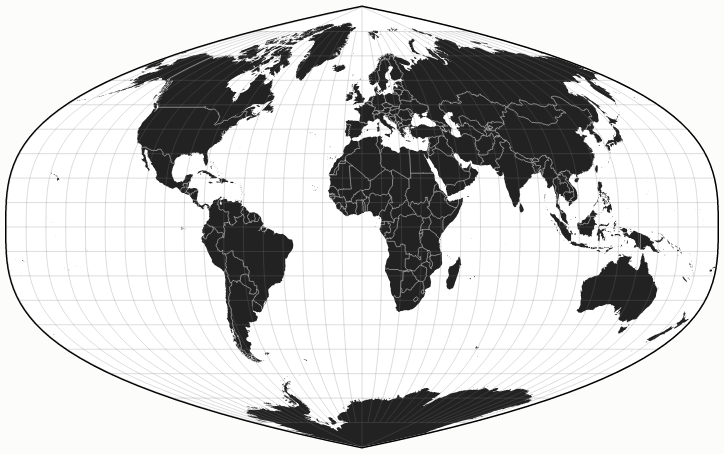
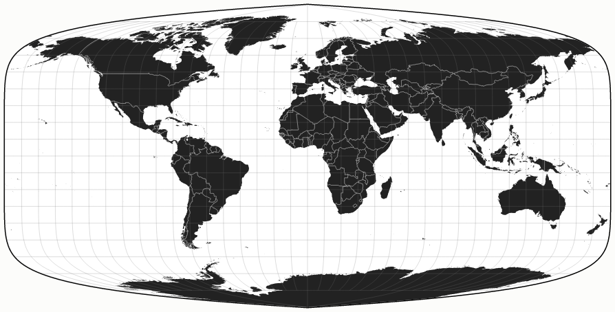
Thanks for those images. I'm trying to post them at this forum. I'll edit this post to show all four images.
These must be:
1. PF3 conformal at the equator
2. PF3 conformal at (lat 45 lon 0)
3. PF8.32 conformaal at the equator
4. PF8.32 conformal at (lat 45, lon 0)
Thanks again for posting the images of those maps!
That's the first time I've seen my map projections.
You've saved me a lot of laborious map-drawing. Your images are posted below, in this posting:
Last edited by RogerOwens on Wed Feb 15, 2017 12:39 pm, edited 1 time in total.
-
RogerOwens
- Posts: 403
- Joined: Sun Feb 02, 2014 8:24 pm
Re: Eckert IV vs Eckert VI. Other related topics.
I've always preferred world maps conformal at the equator, because, as i've consistently said, Africa--shown front & center, large enough to stand out, but small enough to have an expected shape (unlike something as big as the Pacific Ocean)--is all-important for a map's 1st-impression appearance.
So the versions conformal at the equator give a better 1st impression.
But more recently I've realized that decorative appearance isn't the most important purpose of a map, and that conformality at (lat 45, lon 0) balances the shapes better, worldwide.
A high space-efficiency map like PF8.32 cannot give good shapes both at the equator and farther north. As your images demonstrate, when it shows equatorial places with the right shape, PF8.32 dramatically flattens mid-latitude places.
It's the same tradeoff that's inevitable with a cylindrical map. The square-grid version of Cylindrical Equidistant, at first glance, looks better than Gall Isographic, because Africa is the right shape. But, on second glance, we notice that the mid-latitudes are seriously flattened.
As a practical matter of usefulness, I choose the latitudinal shape balance of Gall Isographic, and of PF8.32 conformal at (lat 45, lon 0).
PF8.32-1, your 4th image, can be described as very much like Gall Isographic with point poles. I really like it.
PF8.32-1, #4 among your images, is my favorite, because 1) My purpose with PF is high space-efficiency with point-pole, and 2) I prefer worlwide shape-balance, even it it doesn't make as decorative a 1st impression.
Yes, I'd be most interested in your suggestions on how to make computer-images like that, from a map's formulas. I need all the advice I can get, if I hope to be able to make computer-images of maps.
Thanks again for the images!
Michael Ossipoff
-
daan
- Site Admin
- Posts: 1020
- Joined: Sat Mar 28, 2009 11:17 pm
Re: Eckert IV vs Eckert VI. Other related topics.
In a pseudocylindric projection, the only parallel that could be conformal is the equator. The only other points that could be conformal would be along the central meridian. This series is pseudocylindric. Therefore none of them are conformal along the ±45°parallel or any other parallel that is not the equator.
— daan
— daan
-
RogerOwens
- Posts: 403
- Joined: Sun Feb 02, 2014 8:24 pm
Re: Eckert IV vs Eckert VI. Other related topics.
daan:daan wrote:In a pseudocylindric projection, the only parallel that could be conformal is the equator. The only other points that could be conformal would be along the central meridian. This series is pseudocylindric. Therefore none of them are conformal along the ±45°parallel or any other parallel that is not the equator.
— daan
I didn't say that that any of them was conformal along the 45th parallel.
I said that some are conformal at (lat 45, lon 0)
That is a point on the central meridian.
Michael Ossipoff
-
daan
- Site Admin
- Posts: 1020
- Joined: Sat Mar 28, 2009 11:17 pm
Re: Eckert IV vs Eckert VI. Other related topics.
Right. Apologies for the hasty reading. One of your earlier posts states, “But it makes a lot more sense to have conformality at lat 45. That balances shapes worldwide,” but it’s clear from going over more of the material that you only mean at the central meridian.
— daan
— daan
-
RogerOwens
- Posts: 403
- Joined: Sun Feb 02, 2014 8:24 pm
Re: Eckert IV vs Eckert VI. Other related topics.
PF8.32-1 (the 4th of Tobias's images) has the skinny Africa that I've criticized so much, but PF8.32-1 gets something for that: The combination of pseudocyindricalness, high space-efficiency, & linearity. For all that, some scale-disproportion is unavoidable.
...similar to Gall Isographic. That's probably why Gall Stereographic, Miller Cylindrical & Mercator have been more popular than Gall Isographic. People care more about good shapes than about linearity.
The realistic point-pole makes it possible to show Greenland & Svalbard very well.
The point-pole comes at some cost: Because of it, in order to have the same space-efficiency as Eckert III, it's necessary for the meridians to be more nearly vertically straight, up to a higher latitude, resulting in more cylindrical-like scale-disproportion problem in low or middle latitudes, for a linear map.
So PF8.32-1's Africa probably is a little skinnier than that of an Eckert III that has been horizontally-compressed to make it conformal at (lat 45, lon 0). (But I once calculated that it shouldn't be much more-so.) And PF8.32-2, equal-area & also conformal at (lat 45 lon 0), probably similarly would look a little worse than Eckert IV.
Michael Ossipoff